Municipal Engineers & Township Code Officials
1-888-987-8886(610) 987-9290
Services Offered
GEOGRAPHIC INFORMATION SYSTEMS
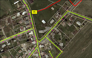
New to GIS?
Let us introduce you to some of the many uses of GIS.
- Municipal Maps including Zoning, SALDO, and Comprehensive Planning
- Act 537 - Sewage Needs Analysis
- Municipal Infrastructure Mapping & Management - Sewer, Potable Water, Roads, Stormwater (MS-4)
- Emergency Management and Environmental Protection Planning
- SEO, Property Maintenance and Code Enforcement Analysis
LTL's GIS Program Goals
Provide GIS Service at appropriate scale for each client.
Provide the most current, accurate, and meaningful data collection and analysis.
Maximize cost effectiveness and efficiency.
Provide customized services for different municipal departments. (Public Works, Administrative, Enforcement, etc...)
Geographic Datasets
We work with the most current datasets available including, but not limited to:
- County Parcel and Assessment
- Color 1' Resolution Aerial Photography
- GPS Collected Datasets
- Survey Based CAD Datasets
- State & National Agencies (PENNDOT, FEMA, USGS)
Other GIS Related Services
Including mapping and database work, LTL Consultants, Lrd. can provide these services.
- Plan Archiving - LTL can scan plans to desired formats, create archives, and link images to GIS maps for easy retrieval.
- Data Collection and Field Work - LTL can conduct water quality sampling, demographic surveying, and GPS data collection to address your planning needs.
- GIS Purchase Support and Training - LTL can help devise programs, and troubleshooting, of your municipal GIS.
Want to know more?
Please feel free to contact us with any questions regarding GIS. At your request, a meeting may be scheduled to discuss how we can address your GIS needs.